
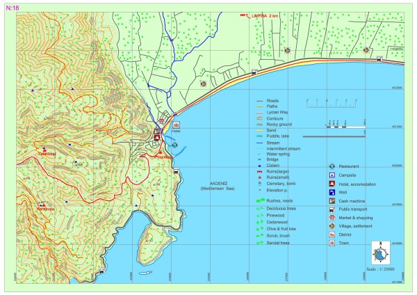
Bonda T. – Finike – Sahilkent
Two paths, coming from south and north, merge further up from the Bonda Hill and around the Dinek Hill. The combined path descends to the Finike district via patches of scrub and pine woods, sometimes intersecting with dirt roads opened for vehicles. While there are no set centers of population along the Lycian road, which will be following the coast for 20 kilometers after the district of Finike, there are some summer houses on the coast.
However, it can well be said that the most suitable location for acquiring food, water, accommodation, etc. is Finike. The archaeological settlement of Arycanda, which is one of the biggest in the region of Lycia, can be accessed after an approximately 1-hour journey with vehicles via the main road that goes north within Finike. If the Lycian road is continued to be followed through Finike, the archaeological settlement of Limyra can be visited after following the creek that goes north from the Sahilkent settlement for a few kilometers.
BOLDAĞ-KARAKUYU SETTLEMENT
Karakuyu, which is one of the various settlements within the region that was called Bonda in the ancient period, on the Gülmez Mountain in the Boldağ Village within Finike District, is in the middle of the Bonda settlement. The steep side of Karakuyu settlement, which extends along the slope of a mountain that is at an altitude of 650 meters from sea level, has a view of Gökliman and is surrounded with walls. It is presumed for these walls to have been part of a castle built for defense against dangers from the north.
On the slopes of the hill, remains of an ancient road can be traced at certain points. A tower of very large architectural parts and the walls that surround it extend along the hill. The door lintels of the domiciles, of which some walls still stand, were constructed with big blocks and have survived until today. The cistern built for supplying water has three vaults and is very interesting in that it can be accessed by descending into it down some steps. Workshops which have been carved into the rock bottom and olive oil mills belonging to these workshops are very common within the settlement. There are earthenware jars within workshops which are understood to have been used for keeping supplies. Sarcophaguses and architectural element of the Byzantine period are concentrated on the southern slopes which have a view of Göklimanı.


These architectural elements belong to the Byzantine period basilica. The ornamented column heads and other ornamental pieces of the basilica are scattered along the slope. Besides the structures which are understood to have been used during the early Byzantine period, the periodical consistency can be observed in structures from the Roman period that have been built of properly shaped stone blocks as well.
YALAKBAŞI SETTLEMENT
Finike is located at a rocky terrain that gets steeper as it gets higher on the side of a strait which extends from east to west 2,5 kilometers north of the Bonda Settlement in Boldağ. An old road that provides passage to the settlement from the Phoinikos harbor city runs through this area. The ancient road passes east to west from the south of a terrace wall made of big stone blocks, along the terracing and ascending slightly. The remains of the road cannot be traced due to the extensive damage on the site.
Besides square shaped workshops of which the vats have been carved into the stone, there are architectural pieces belonging to olive oil mills and circular grindstones, and farm houses on the section of the site that extends east. These areas were used as farm settlement by being reclaimed for agriculture via terracing. The site is also understood to have been used as a holy site in the ancient period due to findings of an altar, pieces belonging to offering stelas and other altars that have been carved into the stone which have holes on the surface and presumed to have been placed to bear bronze offerings.
BOLDAĞ – DİNEKTEPE SETTLEMENT
Dinektepe, which is one of the various settlements within the region that was called Bonda in the ancient period, on the Gülmez Mountain in the Boldağ Village within Finike District, is located on a high hill on north of the Bonda Region at an altitude of 900 meters from sea level. There are patches of agricultural lands on its southwest. This area is generally a Roman settlement. There is a castle with a main structure that has walls of which the thickness is approximately 1 meter and can exceed 1 meter at some parts. This structure is surrounded by many divisions. The inner walls of the castle were generally built of rubble stone while the stones at the foundation are larger stone blocks. The outer walls were built of properly shaped large stone blocks and the tower gate, which is at the height of a single storey and has and entrance from the east, still stands. On the west, there is a structure which is presumed to have had a second storey due to the beam hollows on the top. This structure is built of bossage stones and there are thin connecting walls in the middle that attach the building. Large, connecting stone blocks were used on the lower parts of the wall and indications of past usage in various periods were derived from the little amount of mortared stones. Two towers are presumed to have existed on the mountain side and some domicile buildings can be seen in the inner areas. On the south, a building that is presumed to have existed for service purposes and servants. Some buildings can be accessed via arched passes. There are also workshops and wells within the Dinektepe settlement. There are hollows in the workshops and some rooms are built by being carved into the rock bottom. Grinding vats are mostly preserved. Sarcophaguses which extend from the slopes of the settlement are mostly broken. On some of the sarcophaguses bearing tabulae ansatae with inscriptions (influence of Pisidia), the narrow side bears shield figures while the wider side bears reliefs with lion figures that have medusa faces. The sarcophaguses were built of the regional limestone.
PHOINIKOS
The ancient city of Phoinikos, which is located in the center of the Finike district and has been inhabited from the Hellenistic period, is important due to its geographical position and its fine harbor. The city, which used to be one of the most significant harbor cities of Lycia in the ancient period, still retains its significance due to its topographical structure that on the harbor and the hill behind it and because it connects the south and east of the region via Elmalı. The modern-day settlement has caused a vast amount of damage to the ancient city. Too few of the structures that could be evaluated as examples to military, civil and religious architecture such as city walls, towers, cisterns, rock tombs and sarcophagus elements survived until today. Due to its significant position, the ancient city of Phoinikos has been continuously subjected to sea warfare. In the naval operation carried out by the Romans against the Lycians in 190 BC, the Roman commander Liuius was defeated by the local people. In the year 655, Phoinikos experienced the biggest sea battle between Byzantine and the Islamic Arabian rule which gradually became more powerful in the Mediterranean region. The Egyptian navy and Syrian fleet got together at Phoinikos and attacked the Byzantines who had lost power due to the plague, famine and the Persian invasion in the 6th century; the Byzantine army could show little resistance to the attack. After this battle, Arabian fleets became able to freely roam the Mediterranean coasts. On June 4th, 1606, the members of the Order of Saint Stephen which was founded in Tuscany in the year 1562 by the Grand Duke Cosimo I in order to attack the Ottoman ships and harbor castles, attacked and conquered Phoinikos in 1606. Phoinikos, which is now called Finike, was considered to be an important location at the skirts of the castle by the 17th century Christian knighthood orders and, according to the photograph taken by Italian archaeologists, the tower at the docks still stood in the 1920s. It is presumed that the tower collapsed around the 1950s.
LIMYRA
The ancient city of Limyra covers the acropolis in which early period structures are present and the area right on south of it, within the Roman and Byzantine period walls on the plain which is now divided by the main road. The Lycian name of Limyra, which is one of the important cities of the Lycia Region, is Zemu(ri). The city which has existed from the 5th century BC was used by Pericles, who wanted to establish the Lycian League, as the capital city. The most prosperous era of the city, which is understood to have survived through the 2nd century BC due to the Lycian League coins it has minted, was between the 1st century BC and 2nd century AD when it came under the Roman Empire domination. The city, which was the center of episcopacy under the Byzantine domination, lost its significance after the 7th century. However, the Bektashi Order lodge at Kâfi Baba Shrine in Limyra indicates that the area was of religious importance during the Ottoman period as well. The acropolis, which is located at the northernmost area of the ancient city, consists of a keep at the north and a lower castle. Within the keep, fire altars which reflect the Persian influence on Lycia and especially Limyra are very interesting. There are the city walls, cisterns, the Byzantine church and the Pericles heroon in the lower castle. The mausoleum, which was modeled mostly after the Nereid monument in Xanthos, was built between the years of 390 and 370 BC. The pediment of the structure does not have any reliefs on it. However, the scene in which Bellerophon killed the Chimera is depicted on the southern part of the pediment.
The road, which consists of steps that enable access down the Pericles Monument, is limited to the houses of the Lycian period at the northern entrance of the theatre, which are called the slope houses. The theatre, which is located where the acropolis reaches the plain, of which the original was built in the Hellenistic period and which was rebuilt with the aid of Opramoas after 141 is the most important structure in the city. The Turunçova-Kumluca main road passes over the stage building of this theatre and is of the Roman type theaters in which the seating rows and the stage can be protected from the sun with tents. The south of the main road is divided into two parts by the Limyros creek as east and west. On east, the entrance to the walled section is provided via the gate which is controlled by two rectangular towers near the Kafi Baba Shrine of the Bektashi Order. The “Episcopacy Church” is on the north of the street with ancient columns which extends from this gate, while the “Episcopacy Palace” is on the south. Both buildings are from the Byzantine period. The part that is west of the Limyros creek is surrounded by early Byzantine period walls and contains older remains in comparison to the part on the east. Within the south part of the city walls, a building named “Ptolemaion” has been discovered. The street with columns which extends from the eastern part ends at this building. The roof of this two-storey structure, which has been dedicated to Arsinoe or Berenice, was constructed as to be covered with bay leaves. A small church at the south corner of Ptolemaion has been revealed during the excavations as well.
Another important structure on the western side is the cenotaph that was built for Gaius Caesar, the grandson and foster son of Augustus who died on the 21st February of the year 4 AD at Lymira while returning from his campaign to Syria. The ashes of Gaius Caesar was sent to Rome but this structure was built in Limyra, where he died, by the imperial artists at the behest of Augustus. The ancient city of Limyra is the richest location in Lycia in respect to rock tombs. Limyra is a first in Lycia due to its over 400 rock tombs, most of which are real, and most tombs can be identified with their own names via the Lycian inscriptions on them. The necropolis area of the city, which is on the plains outside and south of the walls, belongs to the period of the Roman Empire.